|

| Print this page - use Landscape |
Search the WeetHet Pages |
|||
| WeetHet is being updated! - Current articles will slowly move to www.tweaking4all.com For excellent webhosting that is reliable and affordable, we highly recommend: LiquidWeb |
||||
|
On this page ...
Overview
GPS (Global Positioning System) consists of 24 Earth-orbiting satellites of NavStar. These satellites allow any person with a GPS receiver to determine his or her precise position, based on longitude, latitude and altitude anywhere on the planet. The fun part is that GPS receivers sell already for
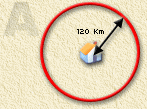
as little as $100. The satellites we use for GPS have been launched for military purpose by NavStar. The first GPS satellite was launched in 1978. The first generation where of the BLOCK I type. The current system is using second generation GPS satellites, of the type BLOCK II. The first BLOCK II satelliet was launched in 1989. The GPS system was fully operational on April 27, 1995. Currently 24 satellites orbit earth at a height of app. 20,000 km (12,500 mi) and circle the earth in 12 hours. Each of these satellites weigh about 775 Kg (app. 1700 lb). It wasn't a cheap system either: costs are estimated at $12 billion US dollars. Up to early 2000, the GPS satellites included an error in their signal for non-military userss, limiting the accuracy. May 2000 this error has been removed. The Russians have an identical system called GLONASS. Tip: more detailed info can be found at NavStar's webiste on GPS or at Garmin (manufacturer of GPS receivers). GPS positioning is based on trilateration. Trilateration is basically, calculating your position based on the distances to at least three known positions. As an example, let's say that you are somewhere in Europe and you are lost -- you don't have a clue where you are. However, you know that the distance to city A is 120 Km. This is pretty useless in itself. You still don't know if you positioned in the North or South of that city. Draw a circle on the map, with a radiums of 120 Km and you'll know that you're somewhere on that line (red line in the drawing below).
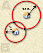
Let's say you also know that you're 50 Km of city B, and you draw another circle on the map, using City B as the centre and having a radius of 50 Km, then you know that you will be on either of the points that intersect with circle A. These point are indicated as black dots in the drwaing below.
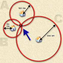
We're getting closer now ... the collection of possible locations is reduced from infinite (the circle) to only 2 locations. Wow! Suppose you also know that the disctance to city C would be 300 Km and you draw circle C (city C as the centre and the radius equal to 300 Km), then only one valid intersection will remain. Your exact position (blue arrow in the drawing below indicates where you must be standing!
Sound pretty simple doesn't it? This 2D concept is being used with GPS - pretty smart thinking eh? Combine this - for GPS - with a 4th location, and imagine the circles being sphere's (we're going 3D now), then you will have altitude as well. The point where all 4 spheres intersect. How is it done in with satellites? For a GPS receiver to find your location, it has to determine two things:
GPS satellites send out radio signals that your GPS
receiver can receive. A GPS receiver measures the time it takes for the signal to travel from the satellite to your GPS-receiver. Since radio signals travels at the speed of light (in vacuum space!), about 299.792 km/s (app. 186,000 m/s), we can figure out how far the signal has traveled by figuring out how long it took to be receiver by you GPS-receiver. Measuring time would be easy if we knew exactly at
what time the signal left the satellite and exactly what time it arrived
at your receiver and our clocks are in sync. Solving the time problem the GPS way. When the satellite's signal reaches the receiver, its transmission of the pattern will be a bit behind or ahead of the receiver's pattern. If clocks would be in sync, then length of the delay is equal to the time of the signal to travel. The receiver multiplies this time by the speed of light to determine how far the signal traveled. If the signal traveled in a straight line, this distance would be the distance to the satellite. Accurate clocks are need for this, because the time measured in these calculations must acurate up to nanoseconds (one nanosecond at the speed of light will result in a pretty long distance to walk!). The Global Positioning System has cool trick to solve this problem. A GPS receiver contains a normal quartz clock. The receiver looks at all the signals it is receiving and uses calculations to find both the exact time and the exact location simultaneously. When you measuring the distance the satellites, you can draw spheres that all intersect at one point, as illustrated earlier. However, due to the clock's being out of sync, the spheres will not intersect at exactly the same point. The error in this point matches the difference in time (OK it's not easy to calculate this - but your GPS receiver is a little computer on itself able to handle this). Applying the inaccuracy to the calculation, will enable the GPS yo calculate exactly where the intersection is. This allows it to adjust its clock matching the atomic
clocks of the satellites. An additional problem is the measure of speed. As we explained earlier, radio signals travel through
a vacuum at the speed of light. A GPS receiver guesses the actual speed of the signal using complex mathematical models of a wide range of atmospheric conditions. Correcting the radio signal behaviour in non-vacuum space. The result will be the exact longitude, latitude and altitude of your position. There is a slight error in this, for the first position to be determined (up to 5 meters accuracy). Since geographers have mapped every corner of the Earth, based on these 3 points you can exactly find where you really are. Several types of maps can be found: for boating, flying, hiking, and driving. |
||||